


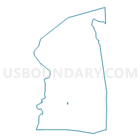
Voting District 0214112, Nassau County, New York
About
Outline

Summary
| Unique Area Identifier | 631470 |
| Name | Voting District 0214112 |
| County | Nassau County |
| State | New York |
| Area (square miles) | 0.03 |
| Land Area (square miles) | 0.02 |
| Water Area (square miles) | 0.01 |
| % of Land Area | 66.83 |
| % of Water Area | 33.17 |
| Latitude of the Internal Point | 40.63377850 |
| Longtitude of the Internal Point | -73.61569650 |
Maps

Graphs
Select a template below for downloading or customizing gragh for Voting District 0214112, Nassau County, New York


Neighbors
Neighoring Voting District (by Name) Neighboring Voting District on the Map
- Voting District 0214110, Nassau County, NY
- Voting District 0214113, Nassau County, NY
- Voting District 0214118, Nassau County, NY
- Voting District 0219074 0219078, Nassau County, NY
- Voting District 0219106, Nassau County, NY
- Voting District 0220044, Nassau County, NY
- Voting District 0220074, Nassau County, NY
Top 10 Neighboring County Subdivision (by Population) Neighboring County Subdivision on the Map
Top 10 Neighboring Place (by Population) Neighboring Place on the Map
Top 10 Neighboring Unified School District (by Population) Neighboring Unified School District on the Map
Top 10 Neighboring State Legislative District Lower Chamber (by Population) Neighboring State Legislative District Lower Chamber on the Map
- Assembly District 14, NY (131,344)
- Assembly District 19, NY (128,933)
- Assembly District 20, NY (128,831)